Showing posts with label planning. Show all posts

Wednesday, December 28, 2011

Post Tsunami: Sendai on the way to revival


I received an email from an old friend, Toru Tanaka, from Sendai, Japan, recently. Sendai is the capital city for Miyagi Prefecture in Japan. It is a city of a million inhabitants. Quite recently, we also got to know Sendai (and its vicinities) as being the area worst hit by the tsunami which overwhelmed the east coast of Japan in March of this year.

One would surely recall the images of destruction played out umpteen times on the television when the earthquake hit the area, only to be swiftly followed right after that by the devastating tsunami. The physical, social and psychological damages to to this island nation have been deep and profound.

But if there is one thing I have learnt from my three year stay in the Land of the Rising Sun, it is that the Japanese are a disciplined, hardworking people with a strong sense of identity.

They will rebuild, recover and rise up again from the disaster. And I'm talking from experience. For I have seen how they've rebuilt Kobe after the Great Hanshin earthquake of 1995.

Being located 10km from the coast, the Sendai city centre itself is not much affected by the tsunami. But the outlying town and villages in the coastal areas were devastated and some have disappeared completely.

Some people are still staying in temporary housing as they still cannot afford to rebuild their homes. But the good news according to Tanaka-san is that the revival plan for Sendai City has been approved at the City Assembly last month. So, a full-scale revival of Sendai is just waiting to happen.

Incidentally, Tanaka-san just got married last September and is building a new life for himself too. He is also now in charge of managing the budget for the road planning program for Sendai.

The beautiful pictures of autumn Japan above were emailed to me by Tanaka-san. It makes me miss Japan. Very much.


Sunday, December 25, 2011

Lyon Light Festival 2011

The City of Lyon by the River Rhone, all lighted up

Lyon is the second biggest city in France located 470km south-east of Paris. The Lyon Light Festival is one of the most famous lighting festivals in Europe. 

The festival has been held every year since medieval France. It has its roots in a religious-related event. But nowadays it has been re-branded into a modern, high-tech lighting festival much anticipated by many in France and near-by neighbouring countries. It attracts some of the best minds and most creative lighting experts in Europe who come to display their flair and hardware.

We were there at the festival to soak in the atmosphere and to see first-hand how a lighting festival is run.

Come 2013, we will have our very own full-fledged world-class lighting festival: The Putrajaya Light Festival.

Watch this space.


Town Planning lessons in Paris

Avenue de La Grande Armee, one of the many boulevards put in place by Haussmann, viewed from  the Arc de Triomphe


I was in Paris two weeks ago. Yes, France, land of the guillotines and home to Zinedine Zidane.

We landed at Charles de Gaulle at 6.20 am and was received by a cold Paris weather with temperature hovering at 5 Celsius. Charles de Gaulle is an old airport. But it is very functional in its design minus all the frills of a so called "modern" airport. For example,  it has proper, separate prayer rooms for all the major religions. Even fancy, modern Changi can't beat that.

The airport is only about 20km away from downtown Paris. But due to the notorious Paris traffic jam, we were forewarned by Thomas, our guide, that the journey would take us a good one hour plus.

We were also told by Thomas that Paris is a city of more than 12 million inhabitants. That's big. But still, that's no excuse for gridlock traffic jams.

Nevertheless, I cannot help but notice that the Paris traffic is a tad more chaotic as compared to say, London or Tokyo. The French drivers also seem a bit more, well, should I say, more of a dare-devil? They'd just weave in and out of their lanes almost without a care for others. And then there are the scooters and motorcycles. Their numbers are noticeably much higher then in other major cities I've been. And their riders are just "super crazy" according to Thomas.

Surprisingly, over the course of one week I was there, I didn't notice any accident. Not even a single one!

Paris is a city of many long straight boulevards lined by trees like the one above. Now this is mainly the work of one fine gentleman by the name of Baron Georges Haussmann. Haussmann was civic planner commissioned by Napoleon III in 1852 to re-plan Paris. 

I had studied Haussmann when I was learning to be a town planner at university. Only now do I see his work with my very own eyes. Quite spectacular and very visionary.

Another feature of Paris town planning are the courtyard building typologies.

The buildings which line the boulevards always seem like they are surrounded on all sides by long, unbroken street walls. Whereas one know very well that many of the buildings are mixed-use buildings accommodating commercial as well as residential elements. So, where are the back-of-house facilities and car parks then?

The answer is that they are right there in the centre of the buildings themselves, within the courtyards.

Now I know better what the planners in Putrajaya are trying to achieve through their urban planning exercise, especially for the Core Island.


Monday, August 15, 2011

Green city initiatives: some British examples


Bicycle hire station, London


Rows of bicycles for hire at a cheap rate, a brain-child of the Mayor of London himself


One of the many electric vehicle charging stations dotted around London


A car belonging to the City Car Club. The club has over 500 low-emission vehicles for people to hire. Car clubs help to reduce car ownership and encourage a transport mix mor ein line with being a sustainable city. This car is a Toyota Prius, a full hybrid electric vehicle


The London Olympic 2012 stadium under construction. The London Olympic aims to be the first Olympic ever to achieve 100% travel by public transport, cycling and by foot. That's 100%!


BedZED (Beddington Zero Energy Development). A zero-energy, environmentally friendly residential development in Hackbridge, Sutton near London. The houses have been designed to use minimum energy for heating and cooling through proper insulation and orientation of the buldings. Only energy from renewable sources generated on site is used. The buildings are also water efficient and constructed using low-impact materials. i.e. they are renewable or recycled materials from within 35 milesof the site, thus minimizing the energy required for their transportation


Walkable city. The new town of Poundbury in Dorchester has been planned based on traditional high-density urban pattern designed to create an integrated community of shops and housing. They are designed and built around the people rather than the car. The world famous architect and urban planner, Leon Krier, prepared the overall concept for Poundbury's master plan


This is an advertisement on the glass window of a restaurant. Instead of displaying the the prices of dishes on offer at the restaurant, it actually shows the amount of carbon emission that one could save (reduce) when one consume each type of dish
 
Small things matter. Even the carton which holds my breakfast egg & mayonnaise sandwhich was manufactured in an environmentally-friendly manner: recycled plastics, recycled paper etc.


The Malaysian Government has announced that Putrajaya - together with Cyberjaya, will be Malaysia's pioneer green city. That announcement was made way back in 2009, during his 2010 Budget Speech.

Not many people understood what that announcement really entails. But almost two years later, the two pioneering cities have managed to make some stride towards becoming Malaysia's true "green cities".

True, a lot still needs to be done. There was a lot of mis-conception. But at least now many understand that being a green city is not about landscaping as in planting more trees.

Green cities, in short, equates low-carbon cities. These are cities with conscious and concerted efforts and programs to reduce carbon emission.

Why the need to reduce carbon emission? It is because the release of carbon into the atmosphere will result in the phenomenon aptly called the "green-house effect" which would lead to global warming. And we all know what global warming means, don't we? Climate changes resulting in  sea level rise and dozens of natural disasters such as flooding, land slides, extreme drought and so on.

So how do we become a low-carbon society? There are numerous ways and means which will contribute to reducing carbon emission. Carbon reduction strategies would cover wide-ranging actions in sectors such as energy, transport, buildings, housing, waste management, and urban planning itself. More specifically, they would include activities like reducing the usage of fossil fuels (petrol, coal), increase utilization of public transportation, reduce long commuting, the use of renewable energy and so on.

Admittedly, we are still new in this. But in more modern societies, low-carbon development and environmentally-friendly life-style is already the way of life. From the housewife who does her waste seperation, right to the taxi driver who would chatter away on how his city is turning green, eveyone understands it and will do their bit to make it a success.

The pics above show some relevant British examples photographed during my trip to the UK last December.

.

Saturday, July 02, 2011

Sungai Perak, our River of Life

Pristine and peaceful Sungai Perak

The boat belonging to JWW Birch anchored on Sg Perak near Belanja, Parit.

Yesterday, I was part of the crowd that gathered to see the PM launch the River of Life Project in KL. The project aims to revitalize the city's dirty rivers and transform the Klang and Gombak rivers into iconic waterfronts on par with waterways in cities like Amsterdam, London and Paris by 2020.

As a town planner, I think this program is laudable.

But isn't it funny how we allow our beautiful natural rivers to be clogged with rubbish and filled with foul effluents in the first place, only to spend billions to reclaim it?

The only plus point is that, according to the PM, this project is expected to contribute RM11 billion to the country's GDP until 2020.Which is good for the nation's economy and the creation of employment.

My late father hails from from Layang-Layang Kiri in Parit, Perak. He was born a stone's throw away from the banks of Sungai Perak. Even though I myself have not even once swum in the mighty Sungai Perak, Apak used to recount tales of how he would swim across the river and back with his friends just for the fun of it. He would tell us stories of how Atok would take his sampan to lead his buffaloes to the small islands which litter the centre of the river where the buffaloes are kept. And how he would spend hours by the river bank till the sun sets, fishing with his buddies.

It is stories like these from my father that makes me captivated with Sungai Perak and rivers in general.

Sungai Perak is, of course, the second longest river in the Peninsula running for about 400km from Hulu Perak down to Bagan Datoh before meeting the Straits of Malacca. Its history is very much intertwined with the history and development of the State of Perak.

The beginning of the current sultanate of Perak can be traced to the event when a descendent of the old Malacca royal family returned to the Peninsula from Sumatera when his entourage landed at Beting Beras Basah near Bagan Datoh in 1528. From there his flotilla sailed upstream along Sungai Perak to set up goverment. He was throned as the Sultan of Muzzafar Shah I, and chose a location on the bank of the river called Tanah Abang in Mukim Bota as his seat of government.

Since then, all sultans of Perak have their seats of government located by the Sungai Perak. There have been 15 of them to date including places like Kota Lama Kanan, Bota and Pulau Cempaka Sari. The current sultan has his seat at Bukit Chandan, Kuala Kangsar.

We are lucky because Sungai Perak is still clean and pristine. Perhaps it's got to do with it being such a big river. But if we aren't careful, with uncontrolled logging and large scale land clearance for development, even a river of this size might succumb to over development and deteriorate in its health.

Although I have not swum in Sungai Perak like Apak, I did have the opportunity to take the Perak River Safari boat ride from Kuala Kangsar to Pulau Cempaka Sari in Parit. I was treated to the sight of quaint riverside villages, buffaloes, monkeys and various flora and fauna of the tropical rain forest that reach down to the water's edge. Fascinating.

As I soaked in the experience, I imagined tracing the journey of the royal flotilla. And I imagined how Apak had swum and played in this beautiful river. And I felt that, whatever happens, Sungai Perak has got to be maintained in its present beauty and splendour.

It is the River of Life for Perak.

.

Friday, June 10, 2011

In Labuan


I’m in Labuan for a working trip.

Labuan, sometimes called the Pearl of Borneo, is an island with a population of nearly 100,000 people. The main town is simply known as  Labuan Town. It was formerly known as Victoria during colonial era.

Labuan used to be part of Brunei rule until the early 1900s. It was briefly under Japanese occupation during World War II before being recaptured by Australian Forces in 1945. It was declared as a Federal Territory in 1984.

My first impression of Labuan is that it is a very clean and tidy little town. Rain trees line the major roads. Although they are not as big as ones you would find in KL or George Town in Penang, I am sure, once they are fully grown, the shades that they would bring would be a boon for pedestrians.  It is already a walkable city. The pedestrian pathways are well maintained and clean. And being a small town where traffic is still manageable, vehicles are slow and do not intimidate pedestrians.

For tourists, the island boasts a Bird Park and some attractive beaches. But the big draw it seems is the Duty Free shopping. Clothes, chocolates and liquors and cigarettes are cheap. During weekends the town would be full of visitors from Brunei which is just an hour’s boat ride away.

But for fishing enthusiasts, Labuan is better known as a world class sport fishing destination. Being surrounded by six smaller islands, the blue

clear water around these islands is said to be home to one of the world's richest coral and fishing grounds which offers unlimited deep-sea tackling catches.


Tuesday, May 17, 2011

Towards a vibrant Putrajaya

Putrajaya is the new Federal Government Administrative Centre for Malaysia. It is the largest integrated urban development project undertaken in the nation.

Being a new town, its planning and development poses its own fair share of  opportunities, and challenges.

Of course being a greenfield development it is fairly easy to plan and lay out the development components as we town planners would see it fit and proper. The developers would then come in and duly start construction as planned. But that, comparatively, is the easy bit. The greater challenge is in building the community and in seeing that the new town prosper and blossom into a vibrant town.

Putrajaya already has a sizable  population of about 69,000. But what it still lacks - for the time being at least - is commercial developments. The Government of Malaysian is keen to see this new city become more vibrant for the locals and visitors alike. That will not happen unless and until there are more commercial complexes, F&B outlets and other retails.

All these have been planned for. Commercial areas have been earmarked within the city right at the outset. What is needed  now is to attract investors and developers to come in and do their bit.

Easier said than done. But of late, big investors - including from overseas - have noticed Putrajaya's potential and started to pour in their money. A lot more needs to be done of course. Promotional activities to attract multinational corporation (MNCs), F&B franchisers and retail anchor tenants would be the way forward.

No point having ample commercial plots if people do not know what you have to offer. And Putrajaya do have lots to offer in terms of recreation, quality services and beautiful natural surroundings and living area.


Saturday, April 16, 2011

Delightful Lumut

Last week I headed to Damai Laut, near Lumut, for a workshop on Structure Plan preparation. Yeah, it's work related...nothing much to do with recreation, unfortunately.

But a short trip to downtown Lumut allowed me to enjoy the delightful little town and helped to clear my mind of work for a bit.

Lumut is a coastal town with a population 31,000 located in the District of Manjung, Perak.

It is fairly famous in its own right, Lumut. It is the home base of the Tentera Laut DiRaja Malaysia and houses the  Naval Dockyard. And of course, it is the gateway to the well-known Pangkor Island.

It is not that big a town. The main shopping area comprises two streets both running parallel to the beachfront. But it oozes some class and has a dignified air about it. It is not only clean and pleasant, but its waterfront is a surprising attraction that one would not normally associate with a small seaside towns in Malaysia (think Kuala Kedah, or Kuala Perlis).

The Lumut Waterfront is a great place to have a walkabout. It is not as big and elaborate as the Kuching Waterfront, but yet it is simple, functional and very presentable as in being aesthetically-pleasing. A plus point is that it was cleverly designed to capitalize on the views towards the water. Supporting facilities are great, too. The toilet is clean and airy - definitely an A+ !

I remember when I was small, Apak would regularly take us to Lumut for its annual Pesta Laut Lumut. Thousands of visitors would throng this small town during this festival. In the days well before Jom Heboh! was created, I guess that was the only means for ordinary folks to have a dose of entertainment and recreation.

The District of Manjung in those days was still called Dindings District. Even much earlier, I mean like in the 1870s, Dindings was part of the Federated Malays States of Penang.

How come! you might ask?

Well it is a result of the infamous Pangkor Declaration in 1874. The Declaration had widespread impact on the history of the Malay Peninsula. It marked the beginning of British intervention in administration of Malay States.

But that is another story for another day.

For now, enjoy some pics of the Lumut waterfront.

Clean, pleasant walkway
Cleverly-designed public toilet complete with a small retail outlet where the shopkeeper doubles as the "gatekeeper" who collects 50 sen form each person who uses the toilet

Plenty of shades and seating areas along the walkway

Monday, April 04, 2011

Korean urbanscape

The Land of the Morning Calm. That's what they call Korea. 

It is a name befitting a nation with a history and culture dating back thousands of years. And when one visits this proud nation, one is sure to be reminded of the rich history and culture of Korea.

I was told by a senior Malaysian Embassy official that the Koreans are on a deliberate campaign to promote all things Korea: from food to music, and from fashion to sports. It is a way of making Korea forever relevant and on the world  map of major international events. Yes, now you know why the K-pop groups and Korean dramas are seemingly invading the local entertainment scenes?

My few visits to Korea has afforded me to observe another aspect of Korean culture - the town planning and its urbanscapes.

An arerial view of a Korean city would not offer much in terms of a feast for the eyes of the architects and planners. The buildings look boxy and whitish all around as far as the eyes can see. It is only when one walks the streets that a Korean city like Seoul would reveal its gems.

Urban pocket parks, city-centre streams, miles and miles of cycling and walking tracks along river banks, and trees lining the steets which would turn all red or yellow when the autumn season comes. These are some of the offerings of the Korean urbanscape that you can expect.


Potted plants in front of a convention centre near Incheon

Man-made water body complements a park in Songdo City

Public art sculputre in front pf convention centre in Sonngdo City

Pavement directional signage in Nam Daemun, a traditional shopping area in Seoul

A new park in Songdo City near Incheon


A city centre urban park in Seoul. This one is located in between two three-laned highways. It has lawns, flower plants, and water features

The same urban park in Seoul. You can see how popular it is with visitors

Cycle path and shrubs bordering a four-laned urban highway in New Songdo City near Incheon

Friday, February 18, 2011

Skyscrapers in Putrajaya


It has been fifteen years since construction first started in Putrajaya. For the first ten years, most developments have been for government office buildings and government residential quarters.

Over the last five years though, one is able to witness commercial office developments come on line. And this trend looks set to continue.

As the development of government buildings come to a tail end, and especially as the population size of the city continues to rise, the private sector has finally got Putrajaya on their radar.

This is surely a sign of the city maturing. For it is now capable of attracting private commercial investors big time. Well, almost.

I am sure that it won't be long before Putrajaya will be able to give KL a run for its money and boast its own beautiful, high-rise commercial buildings. When that happens, MNCs (multinational corporations) will be making a bee line towards Putrajaya...so eat your heart out KL.

For now, Putrajaya already has its first four skyscrapers - albeit in the form of government ministry buildings.


.

Saturday, February 12, 2011

Pameran 1 dekad kecemerlangan Putrajaya


Sempena Karnival Wow! Putrajaya, suatu pameran sedang diadakan di Presint 2 Putrajaya bertemakan 1 Dekad Kecemerlangan Putrajaya.

Karnival serta pameran ini berlangsung dari 11 hingga 13 Februari 2011, iaitu sempena sambutan Bulan Wilayah Persekutuan.

.

Friday, January 07, 2011

Manchester city transport


Manchester is the second (or is it the third) biggest city in the UK. But it was, of course, the birth place of the British Industrial Revolution in the 18th century.

To this day one could still find the many large buildings which used to house the cotton mills and warehouses back then scattered throughout the city.

Within the very centre of the city one would witness winding, narrow streets laid out close to each other suitable for, and reflecting perhaps, the typical transport requirements of the day back then which was most probably horse-drawn carriages.

During the 19th century Manchester used to have its own tram system. But later, like in most UK cities (bar Blackpool), the trams disappeared which only served to bolster the position of automobiles as the undisputed Kings of the Road.

Credit to the city's planners, the trams were brought back to the city centre in time for the Commonwealth Games 2002. They are now a permanent feature in the Manchester streetscape.

Before the trams made their comeback there was of course the buses.

I used to take the No. 81 Greater Manchester Transport bus from Cheetham Hill to the university. But after a few weeks of riding on the smoked-filled buses (there were no smoking restrictions back then in the 1980s) I gave up.

You see, the cigarette smoke would make me dizzy and sick every time I ride the bus. So I bought myself a cheap second-hand Ford Escort which would ferry me to school everyday as and when I pleased.

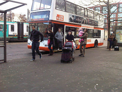
Note: pic shows a town bus at the Piccadilly Gardens bus station, Manchester.

Sunday, April 25, 2010

Why I ride in Putrajaya

Putrajaya was planned to be a garden city.

It was deliberately designed to see greeneries in abundance and where its citizens would have nature at their doorsteps, so to speak.

Such planning has seen Putrajaya developing into a city where nature is woven seamlessly into the urban fabric. The lake, wetlands system, the wooded areas and endless green corridors, as well as the promenade all add up to an urban nature sanctuary bar none, dare I say.

This means that Putrajaya has - inadvertently perhaps - turned into a heaven for cycling.

For, besides the Putrajaya Challenge Park which is now well on the way to becoming a "must ride" venue for every mtb enthusiast worth his salt, you also have the trails in the wetlands and the kilometers of promenade which offer interesting rides within cool, shaded environment with the sounds of insects and birds chirping in the background.

And, by the way, Putrajaya also hosts the monthly Putrajaya Critical Mass.

Enjoy some pics taken during my morning ride in Putrajaya Wetland today with three of my riding buddies: Pak Adib, his son Maher, and Maher's office colleague Henri.


Pak Adib and gang preparing for the ride

Cool, crisp morning air - fresh air!

The lone rider: being one with nature

Lake side wakaf stop

Tranquil, serene place for respite


Wildlife in the wetlands

Macho riders

Putrajaya Lake/wetland

Pak Adib: he walks, he cycles, and now he wants to sail too! Seen here looking longingly at a boat

.

SAHABAT SEJATI DAN BERMUSAFIRAN

  “ Tidakkah mereka berjalan di muka bumi, lalu mereka mempunyai hati yang dengannya mereka dapat memahami… ” (Surah Al-Hajj : ayat 46) Saha...